

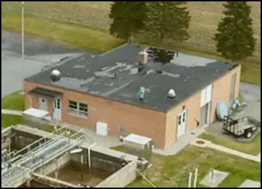
What's Causing the Rain Damage?
A strong rain storm can leave a path of destruction in its wake with many business and commercial buildings suffering damage from high winds, heavy rain, fallen trees, or flying debris. Assessing the structural and environmental integrity of your facility is crucial in the aftermath of a significant storm.
DRONE APPLICATION: Our pilots can quickly capture details and document current conditions in hard-to-reach places.
A strong rain storm can leave a path of destruction in its wake with many business and commercial buildings suffering damage from high winds, heavy rain, fallen trees, or flying debris. Assessing the structural and environmental integrity of your facility is crucial in the aftermath of a significant storm.
What are common causes?
- Poor Drainage - If you have a flat roof and it’s not draining properly, you run the risk of ponding water. And the weight of this accumulated water can cause structural issues for the building.
- Aging System - Over the years, wear and tear on your roof may result in damage to the flashing or roof membrane cover. Wind, debris, or extreme temperatures may cause the flashing to become loose or the membrane to puncture or tear. This damage provides the water and moisture a place to go – resulting in leaks and mold in the building.
- Poor Seals - There are intentional holes in the roof membrane cover for such necessities as HVAC units, drains, or vents. If the wraps, rain collars, or pitch pans at these areas are not water-tight rain water and moisture enter the building.
Although the damage may appear to be minimal, water intrusion caused by the storm or structural damage to the building may not be readily visible; but if it’s not addressed promptly, could result in further property damage, mold growth, or other biological issues.
Did you know that mold can grow in as little as 12 hours?
Mold is one of the leading Indoor Air Quality problems, often causing significant allergies and health problems for occupants. Mold can grow almost anywhere there is water damage, high humidity, or dampness. If such conditions exist in your building, you most likely have a mold problem.
SSM’s structural engineers and Indoor Environmental Quality Specialists can evaluate the existing conditions, determine the extent of the damage or water intrusion and recommend corrective actions before conditions effect occupant health.

Digitizing Hard Copy Maps
Advancements in GIS software and mobile applications have recently provided the ability to access maps and data on the go.
For decades, public utility providers and municipalities have used paper maps to maintain and keep track of their assets. Too often, these bulky, hard copy maps are still being utilized today, but many of SSM’s clients are opting to digitize their utility maps. Advancements in GIS software and mobile applications have recently provided the ability to access maps and data on the go. This allows managers and operators to access asset locations, specifications, photos, and customized maps and applications wherever they take their mobile device. For many, digitizing old maps is well worth the process.
The process begins by scanning the paper maps. Once the maps are scanned as an image file, they are then georeferenced using GIS software. This assigns real world coordinates to the image, allowing the features to be traced as a shapefile. Depending on how old the map is, or how accurately it was originally created, some inferring may be required to correctly place the data. After the data is digitized, it’s best to verify the locations, as things may have changed since the maps were originally created. Now you can access the data whenever and wherever you need it via computer, smartphone and/or tablet.

Online GIS Applications: A low-cost Asset Management Approach
Many water/wastewater systems use online GIS applications to transform their infrastructure data into an easy-to-use operations asset management system.
Geographic Information Systems (GIS) emerged in the 1970s and became accessible enough for deployment within local government and utility companies in the 1990’s. For the past 20 years, municipal authorities were sold on the power of GIS in asset management. But after investment in the hardware, software, and data conversion, many small water and wastewater systems found themselves with a system that is not living up to their expectations. Cost-cutting measures may have relegated updating and maintaining the GIS data to in-house operators with whisper-down-the-lane training. Hesitant to invest in a poorly-understood system, but eager to capitalize on the benefits, small utilities are seeking a low-cost, effective asset management approach. Recent advancements in web-based GIS applications, similar to Google Earth, have provided new means to create, store, and access GIS data.
Many water/wastewater systems use online GIS applications to transform their infrastructure data into an easy-to-use operations asset management system. This low-cost approach captures vital data within a secure geo-spatial database. By creating customized mobile web applications, field-critical data (material description, installation date, inspection reports and service history) is available when needed most and accessible to operators in the office or in the field.
Large water utility companies have invested significant capital resources in data capture, mapping, and management of their system assets. The massive amount of the data is contained within a centralized enterprise GIS database and made accessible by credentialed users. Operation and maintenance of large GIS datasets are conducted by a full-time GIS department. Small water systems would benefit from the same access to a GIS database, but are unable to dedicate the resources necessary to collect and maintain the asset data. An online GIS approach uses a similar data model, but scaled down to the appropriate size to meet the financial structure of the system.
The process of building an online GIS data system begins with the conversion of as-built plans to geographic data. Old paper maps are scanned to an image file. Through a process of georeferencing, the map is given a map coordinate projection. The features of the map are digitized to populate the geodatabase with geometry and attribute features. The geometry features are the geographic locations of the features, such as the exact location a fire hydrant or the run of a pipe. The attribute features are the information that is associated with each individual asset. Everything from the manufacturer and serial number to maintenance and performance history can be associated with an individual piece of equipment. Notes and annotation from the paper maps, such as “turns right” on valves, can be added to the attribute features to preserve institutional information about the system. The resultant geodatabase can be completely customized to the needs of the individual system.
Once the geodatabase is built, the data is presented in the form of online map applications. The locational data is visualized on a variety of basemaps, be it parcel street maps (as example below) or areal imagery. Selecting a feature brings up the relevant information regarding that feature. The maps are accessible to any device with a connection to the internet. That means an operator in the field, using his smart phone or tablet, will have the same access to the system information as a manager, sitting in the office at his computer.

Seize an Opportunity
When condition dictates end-of-life replacement of HVAC systems, it offers an opportunity to consider retrofits that will enhance energy efficiency, capacity, control and service. Two recent projects illustrate this opportunity seized.
When condition dictates end-of-life replacement of HVAC systems, it offers an opportunity to consider retrofits that will enhance energy efficiency, capacity, control and service. Two recent projects illustrate this opportunity seized.
A recently completed $2.5M central plant upgrade was an End-of-Life Replacement project for 40-year old steam chillers supporting a 750,000 SF research center that increased the plant capacity from 5900 tons to 7300 tons (and the firm capacity from 4400 tons to 5400 tons) with an efficient system for greater service and better control. The project included the design for installation of a temporary chiller and cooling tower to support the building load during the full system shutdown for installation of the tie-ins of the new equipment.
A study was initially undertaken to determine the maximum cost effective capacity expansion for the plant; its purpose was to establish a limit for the cooling load that could be accommodated at the facility and then construct an energy efficient system to provide that capacity. The limiting factor was determined to be the distribution infrastructure due to cost prohibitive upgrades necessary to “max out” the distribution systems capabilities; therefore the increased plant capacity was designed to match the reasonable capacity of the main arteries of the distribution system. Almost $60,000/year of electric savings were achieved by installing a “free-cooling” system using condenser water during the winter months to create chilled water, reducing the chiller plant hours of operation from 8,760/year to 5,200/year and would allow a shutdown of the chillers during the winter. Including the free-cooling savings, the project reduced annual costs over 45%.
For a Mission Critical Data Center ($1.7M update) the need to replace the existing cooling towers that had reached their End-of-Life provided the opportunity to upgrade and modify the chiller plant to include “free cooling” by the condenser water system and to decouple the cooling towers and chillers to allow for more options in the operation of the chiller plant relative to redundancy resulting in $55,000 savings/year. An existing 3,000 ton cooling tower system was exchanged with new more efficient towers and a reconfigured
piping system to allow winter “free cooling” by the condenser water system. The system was designed to allow parallel operation of the cooling towers with one system in support of chiller cooling and another to operate as “free cooling” until full capacity “free cooling” was available. The design featured phased construction to maintain full site operation with N+1 component availability during the construction period. A new Sequence of Operation for the Condenser Water System and Chiller Plant for full automatic control by the Building Management System was prepared to provide for automatic reaction to a loss of system performance as required for a Tier 3 facility. In addition to the primary chiller and condenser water systems, a chemical treatment system was designed to provide year round treatment of the condenser water regardless of system operation in Chiller Cooling or Free Cooling mode.
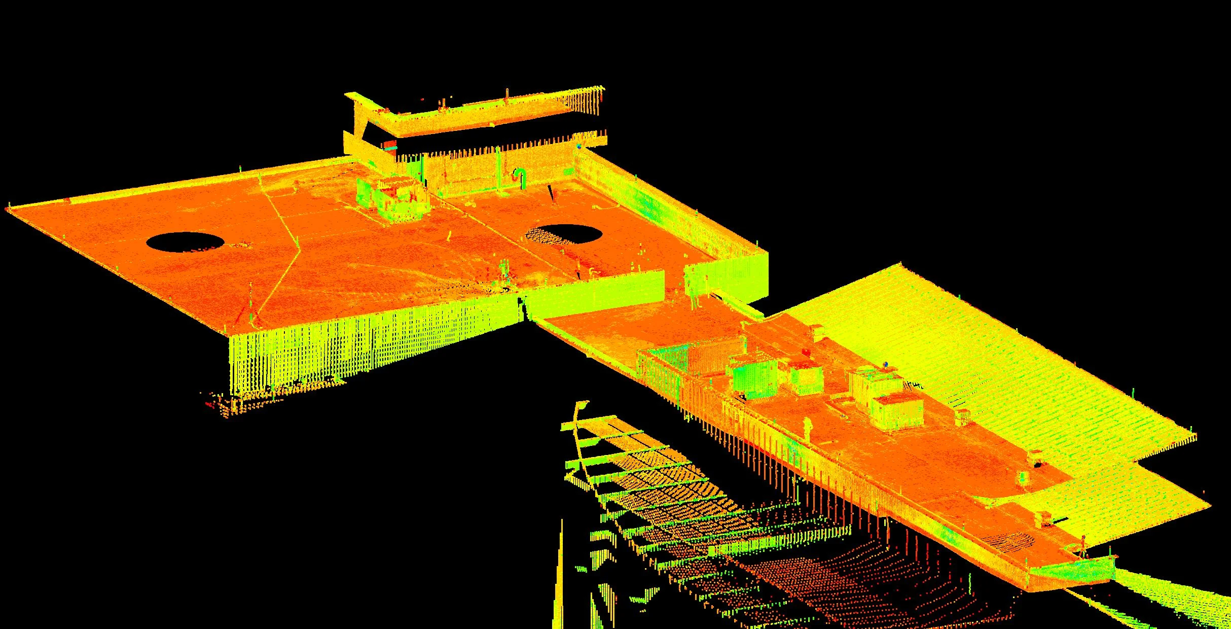
Small Imperfections Matter
From high-speed racetracks to concrete floors measuring and modeling large surfaces can highlight small imperfections.
For complex surfaces or large areas of surfaces that require high levels of flatness or levelness, using a high definition laser scanner offers millions of coordinate data points for verification or detection of anomalies that cannot otherwise easily or quickly be acquired. From offices to high density storage facilities, synthetic surface playing fields, to high-speed race tracks, the ability to rapidly and accurately measure and model large surfaces can highlight the small imperfections that can make a big difference.

In West Whiteland Township, post-construction high definition surveying was utilized over 12,000 square feet of concrete floor to identify irregularities in placement that prohibited the installation of finishes, equipment and furnishings. Contour plans with color banding and spot elevations to demonstrate where problem areas were located, with 1/8-inch accuracy aided the client and contractors to swiftly repair and to rule out structural deficiencies. A similar analysis was performed for the roof to identify slope and stormwater drain placement.
FOR MORE INFORMATION: Patrick McCoy, PE, LEED AP, CSDP

It's the Little Things that Matter in Stormwater Management
There are many ways to attack a stormwater management issue, and in a large watershed, the task can seem daunting. But when you stop and think about it, it really comes down to identifying, prioritizing, and properly managing small areas of land within the larger watershed.
With the Chesapeake Bay Reboot and new MS4 permit requirements hitting municipalities, many are left asking, “How can we possibly accomplish this?” There are many ways to attack a stormwater management issue, and in a large watershed, the task can seem daunting. But when you stop and think about it, it really comes down to identifying, prioritizing, and properly managing small areas of land within the larger watershed. The combined impact of small BMP projects on a watershed can be astounding, and are only amplified as one moves downstream.
At Spotts, Stevens and McCoy, we’re able to help our clients find the most cost efficient way of achieving their permit and pollution reduction goals. By utilizing mapping and modeling software, such as ArcMap, MapShed, and the BayFAST models, we’re able to get an idea as to how current land uses and activities within MS4 limits impact local waterways. We can also make adjustments for any existing BMPs, and plan for the future by determining the most cost efficient BMPs, and the location in which they’ll have the biggest impact on water quality. For instance, planting a rain garden down-gradient of a large parking lot could have a bigger impact on water quality than the same rain garden in a grassy park.
When we look at water quality issues at the local level, as opposed to a large watershed scale, not only are the concepts and goals more reasonable and achievable, but we’re able to engage the community to do their part. Instead of worrying about cleaning up the bay downstream, worry about cleaning up your local streams. These little actions can lead to big impacts. Residents will take pride in BMP projects and results, and will get excited about being able to use the waterways for recreation and fishing. As a bonus, you’ll still be doing your part in helping your downstream neighbors.
FOR MORE INFORMATION: Ashton Hogarth, Environmental Specialist

An example of how stormwater BMPs can be situated so as to achieve the greatest impact on water quality (images from the PA DEP Bureau of Watershed Management “Pennsylvania Stormwater Best Practices Manual”, Chapter 6)

Three Small Things that Can Make a BIG Difference in the Bottom Line
There are three areas that can provide big savings in WWTP Operations: energy usage, chemical addition, and sludge generation and disposal
Inefficiencies in Municipal Wastewater Treatment Plants
Many Wastewater Treatment Plants (WWTP) were built at a time when budgets were not so tight and engineers erred on the side of caution to ensure that the plant met the design criteria. Many WWTP operators only have experience at one WWTP where they learned the trade from the previous operator. Those operators may have learned how to run the plant from the engineer who designed the facility and never changed their operations approach to adapt with the times.
What some call the municipal approach, “if a little is good, more must be better”, is often seen at smaller plants. This can lead to many unseen expenses. There are three areas that can provide big savings: energy usage, chemical addition, and sludge generation and disposal
The largest typical waste of energy in a WWTP is over aerating. The specific amount of air needed for a well running plant varies with the type of treatment process and the control capabilities. Activated sludge plants require a specific volume of air for BOD removal and nitrification. Online dissolved oxygen monitoring equipment can lead to a very efficient system if the associated controls are installed at the blowers. If these controls are not available, the operator has to select blower settings that allow for the plant to operate within the desired dissolved oxygen levels for the longest period of time possible. Dissolved oxygen will vary with changes of temperatures meaning that spring and fall are the most difficult seasons to maintain consistent dissolved oxygen levels.
Chemical addition is an area where waste often occurs. The ideal way to determine appropriate dosage is to perform jar tests. You add various dosages of chemicals to equal volumes of sample to determine which dosage provides the best flocculation and settlings to achieve desired treatment results. Overdosing of chemicals can lead to excess floc formation, sludge generation, and inhibit settling. If a facility doesn’t have the ability to perform jar tests, a chemical representative will typically give you a starting dosage and adjustments can be made by using visual analysis and laboratory data.
Sludge generation can be impacted by multiple operations approaches. Overdosing chemicals can lead to excess sludge generation and disposal requirements. Excess wasting can also generate increased levels of sludge. Each biological process requires sufficient biomass to treat the level of contaminants in the waste stream. Proper monitoring and control of the biomass will lead to optimum levels of sludge generation.
Multiple options are available to achieve cost effective disposal of the sludge generated from the treatment process. The majority of plants contract to have sludge hauled off-site. The volume of sludge to be hauled can be managed through various thickening processes selected by considering cost of the thickening equipment vs. actual hauling costs. Disposal options range from the least expensive, agricultural land application, to mine reclamation and landfill disposal, which is typically the most expensive disposal method. Some facilities have reed beds which have no annual disposal costs, but require a large capital outlay when they need to be cleaned out. A few facilities have incinerators which are labor intensive and come with high operating and maintenance costs.
The bottom line is that small changes in the treatment process can have a significant impact on the cost of operations. SSM can provide assistance to optimize operating costs for municipal facilities searching for budget dollars.
FOR MORE INFORMATION: Carl Kline, LO