

Lead and Copper Rule Revisions: GIS for Service Line Inventory
EPA recently revised the Lead and Copper Rule, establishing compliance deadlines of October 2024. To jumpstart the road to compliance, water systems should consider deploying a GIS team to establish their service line inventory. Likewise, water systems should ensure they have an engineering team on board that is well-versed in providing engineering design and consulting services.
Understanding the Lead and Copper Rule Revisions
In 2021, the U.S. Environmental Protection Agency (EPA) issued revisions to the Lead and Copper Rule that was first enacted in 1991. The new revisions intend to better protect children and communities from the risks of lead exposure in water. The revisions focus on taking more robust steps to get lead out of drinking water, as well as better informing communities and protecting children at schools and childcare facilities.
Required lead testing in schools and childcare facilities
Establishment of a “trigger level” to enable earlier mitigation
Use of science-based testing protocols to identify more sources of lead
Driving more full replacements of lead service lines
Development and maintenance of a public inventory of water service lines
The revisions to the Lead and Copper rule establish one of the largest updates to water regulation in 30 years. The rule is also accompanied by significant federal dollars available to assist community water systems (CWSs) with their plans for ridding the risk of lead in drinking water. The regulatory compliance deadline for water systems to meet the rule revisions is October of 2024.
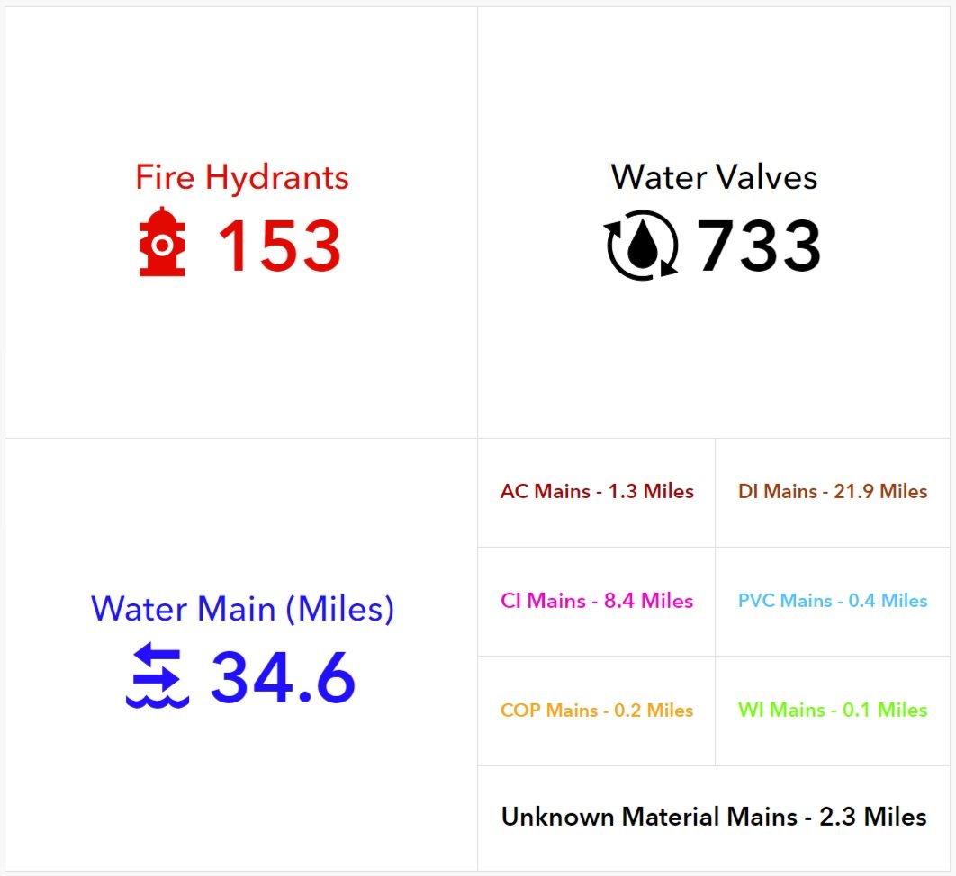
Sample of GIS data dashboard
Managing the Public Service Line Inventory with GIS
Among the revisions, EPA is requiring every water system provider to complete an inventory of their water service lines and report it. If done appropriately, this resource could aid in long-term planning and compliance including laying the groundwork for service line replacement plans as well as managing and tracking improvements and testing records.
A GIS dashboard, built around your water system means your data is always up to date and always accessible. In lieu of paper collection, management of assets can now be done through smart devices, in the field, with next to real-time updates. And accessing that information is easier than ever before. Your data can be built exactly the way that you need it - accompanying the location, analyzed alongside your capital planning, or summative looking at the whole picture.
Whether you're building your inventory from scratch or modifying your existing database - having a GIS team on board means that you data will start to work for you.
Our GIS team is well-versed in aiding our clients with the collection, documentation, and delivery of both private and public-facing dashboards as well as data analysis that ensures your data turns into an interactive, visual asset. This means all of that information becomes meaningful - saving you time and resources. The goal is not just to build a compliant service line industry. It’s to build one that is also valuable to you. To build an inventory that provides direction, meaning, and protection for you and your community.

The Right Time to Start your Service Line Inventory
The short answer to this common question is: now. While the deadline for compliance with the Lead and Copper Rule revisions isn’t until October 2024, it’s important to get your plan into action as soon as possible. A full inventory collection can be a time intensive process, particularly without deploying modern collection methods. It is recommended that the development of your inventory is as thorough as possible including the required historical records and assessment for replacement. Considering all of this, jumpstarting your inventory collection and database building now is crucial to compliance by 2024.
A great first step is to identify where you currently stand in the road to compliance. Then, assess the opportunities that a GIS team presents for preparing and managing your inventory moving forward.
SSM’s GIS Experience
For more than 20 years, we’ve provided professional GIS services to our clients; from mapping support for infrastructure projects, to focused GIS and data capture projects. We utilize GIS to analyze, visualize, and interpret data to understand patterns, relationships, and trends. Through SSM’s extensive geographic data our clients benefit from faster project startups and the economies of readily available data. SSM’s GIS Asset Management approach helps municipalities to transform water, sewer, storm water, or transportation infrastructure data into an easy-to-use operations asset management system capturing vital infrastructure data points with survey-grade accuracy. The data is verified and compiled into a geo-spatial database. Most of our water/wastewater clients have reaped the benefits of GIS in both their everyday use and long-term planning.
Compliance with Testing Protocols and Service Line Replacement
In addition to our GIS expertise, we have dedicated engineers with water system expertise. Our team of Process and Design Engineers have deep and long-standing experience providing water and wastewater engineering services. A significant number of our staff have more than 20 years of experience serving water and wastewater authorities. We combine professional engineers, professional land surveyors, environmental scientists, designers and drafters into teams to complete each assignment.
When it comes to managing and protecting water resources, SSM is the authority that everyone turns to. SSM offers extraordinary experience in the planning, design, and construction management of wastewater and water systems, piping systems, pumping stations, and treatment plants.
As you continue your planning for compliance with the Lead and Copper Rule Revisions, ensure your engineering team is ready and available to get you there not only with expertise, but with experience.



Lead and Copper Rule Revisions: GIS for Service Line Inventory
EPA recently revised the Lead and Copper Rule, establishing compliance deadlines of October 2024. To jumpstart the road to compliance, water systems should consider deploying a GIS team to establish their service line inventory. Likewise, water systems should ensure they have an engineering team on board that is well-versed in providing engineering design and consulting services.
Understanding the Lead and Copper Rule Revisions
In 2021, the U.S. Environmental Protection Agency (EPA) issued revisions to the Lead and Copper Rule that was first enacted in 1991. The new revisions intend to better protect children and communities from the risks of lead exposure in water. The revisions focus on taking more robust steps to get lead out of drinking water, as well as better informing communities and protecting children at schools and childcare facilities.
Required lead testing in schools and childcare facilities
Establishment of a “trigger level” to enable earlier mitigation
Use of science-based testing protocols to identify more sources of lead
Driving more full replacements of lead service lines
Development and maintenance of a public inventory of water service lines
The revisions to the Lead and Copper rule establish one of the largest updates to water regulation in 30 years. The rule is also accompanied by significant federal dollars available to assist community water systems (CWSs) with their plans for ridding the risk of lead in drinking water. The regulatory compliance deadline for water systems to meet the rule revisions is October of 2024.
Sample of GIS data dashboard
Managing the Public Service Line Inventory with GIS
Among the revisions, EPA is requiring every water system provider to complete an inventory of their water service lines and report it. If done appropriately, this resource could aid in long-term planning and compliance including laying the groundwork for service line replacement plans as well as managing and tracking improvements and testing records.
A GIS dashboard, built around your water system means your data is always up to date and always accessible. In lieu of paper collection, management of assets can now be done through smart devices, in the field, with next to real-time updates. And accessing that information is easier than ever before. Your data can be built exactly the way that you need it - accompanying the location, analyzed alongside your capital planning, or summative looking at the whole picture.
Whether you're building your inventory from scratch or modifying your existing database - having a GIS team on board means that you data will start to work for you.
Our GIS team is well-versed in aiding our clients with the collection, documentation, and delivery of both private and public-facing dashboards as well as data analysis that ensures your data turns into an interactive, visual asset. This means all of that information becomes meaningful - saving you time and resources. The goal is not just to build a compliant service line industry. It’s to build one that is also valuable to you. To build an inventory that provides direction, meaning, and protection for you and your community.
The Right Time to Start your Service Line Inventory
The short answer to this common question is: now. While the deadline for compliance with the Lead and Copper Rule revisions isn’t until October 2024, it’s important to get your plan into action as soon as possible. A full inventory collection can be a time intensive process, particularly without deploying modern collection methods. It is recommended that the development of your inventory is as thorough as possible including the required historical records and assessment for replacement. Considering all of this, jumpstarting your inventory collection and database building now is crucial to compliance by 2024.
A great first step is to identify where you currently stand in the road to compliance. Then, assess the opportunities that a GIS team presents for preparing and managing your inventory moving forward.
SSM’s GIS Experience
For more than 20 years, we’ve provided professional GIS services to our clients; from mapping support for infrastructure projects, to focused GIS and data capture projects. We utilize GIS to analyze, visualize, and interpret data to understand patterns, relationships, and trends. Through SSM’s extensive geographic data our clients benefit from faster project startups and the economies of readily available data. SSM’s GIS Asset Management approach helps municipalities to transform water, sewer, storm water, or transportation infrastructure data into an easy-to-use operations asset management system capturing vital infrastructure data points with survey-grade accuracy. The data is verified and compiled into a geo-spatial database. Most of our water/wastewater clients have reaped the benefits of GIS in both their everyday use and long-term planning.
Compliance with Testing Protocols and Service Line Replacement
In addition to our GIS expertise, we have dedicated engineers with water system expertise. Our team of Process and Design Engineers have deep and long-standing experience providing water and wastewater engineering services. A significant number of our staff have more than 20 years of experience serving water and wastewater authorities. We combine professional engineers, professional land surveyors, environmental scientists, designers and drafters into teams to complete each assignment.
When it comes to managing and protecting water resources, SSM is the authority that everyone turns to. SSM offers extraordinary experience in the planning, design, and construction management of wastewater and water systems, piping systems, pumping stations, and treatment plants.
As you continue your planning for compliance with the Lead and Copper Rule Revisions, ensure your engineering team is ready and available to get you there not only with expertise, but with experience.

GIS Services
SSM provides professional GIS services to; from mapping support for infrastructure projects, to focused GIS and data capture projects

SSM provides professional GIS services from mapping support for infrastructure projects, to focused GIS and data capture projects. We utilize GIS to analyze, visualize, and interpret data to understand patterns, relationships, and trends. Through SSM’s extensive geographic data our clients benefit from faster project startups and the economies of readily available data.
We don’t just implement GIS for our clients; we use it throughout SSM, every day. We evaluate, design, and implement institutional data to improve decisions and streamline project workflow.
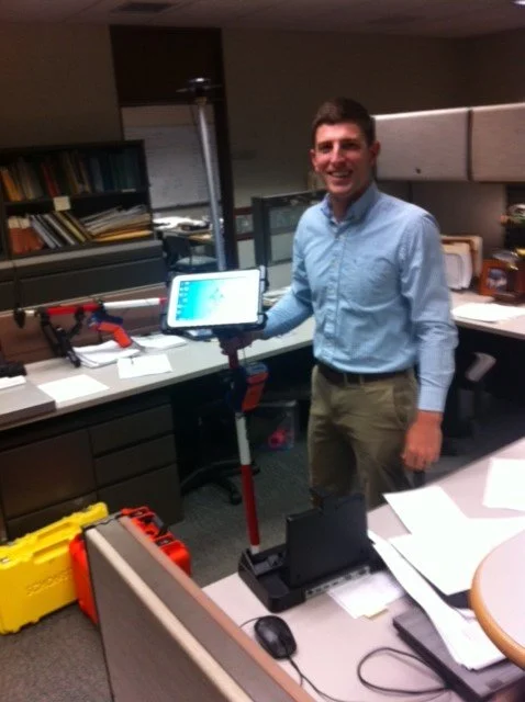
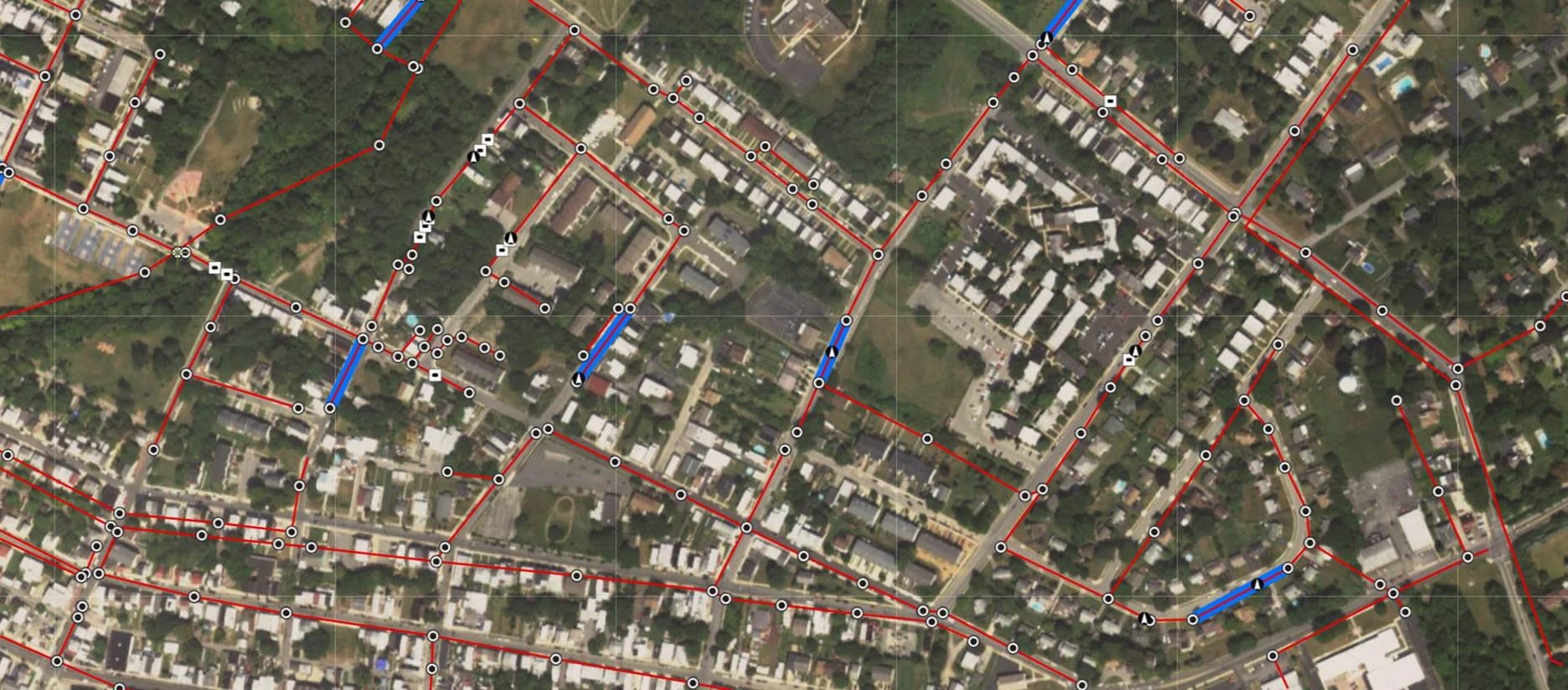
SSM’s GIS Asset Management approach helps municipalities to transform water, sewer, storm water, or transportation infrastructure data into an easy-to-use operations asset management system capturing vital infrastructure data points with survey-grade accuracy. The data is verified and compiled into a geo-spatial database. By creating customized mobile web applications, the field-critical data, such as material description, installation date, inspection reports and service history, is available at your finger-tips when you need it most.
GIS Data Management: Five things you need to know
With GIS technologies, information is no longer stored in multiple locations-maps, spreadsheets, notepads, clipboards, cell phones, email chains-but can now be stored in one spot. This helps you save time, improve processes, and get the information you need when you need it, wherever you are.
There is a data issue affecting facilities, municipalities, businesses, and organizations. Data is collected, sorted, resorted, and sorted again with little to no reward for the time and labor-consuming effort. Or worse- valuable data is left untouched, and unused.
With GIS technologies, you can make your data work for you. Information is no longer stored in multiple locations-maps, spreadsheets, notepads, clipboards, cell phones, email chains-but can now be stored in one spot.
With GIS, you can save time, improve processes, and get the information you need when you need it, wherever you are.
#1 - You use GIS every single day.

GIS technology connects the "where" with the "what". Geographic information combined with attributes, or "everything you need to know". Looking to buy or rent a home? Those phone apps are so convenient - open up the map, choose the location, and it shows all of the homes along with data about their price, their age, and more. Surprise! You just engaged with GIS. All the data ... one single spot.
What about when you are driving somewhere new? Do you utilize maps on your phone to locate the nearest gas station or coffee shop? You’re utilizing GIS! Have you noticed those roads turn red when there’s traffic? That’s all data, displaying in one interactive map. The help that comes if you are ever in an emergency? The responders depend on GIS. Google Earth- where you look up your own home for fun? GIS. GIS is something you use and benefit from every day, even if you are unaware of it.
#2 - It's nothing new. But it is constantly getting better.
At SSM, we've been providing clients with GIS Services for more than twenty years. When spatial databases were an idea of the future, we were there, signing our first GIS clients and leading the charge in making data meaningful.
With every new advancement in technology, we're finding new and better ways to help our clients raise efficiency. Finding new and easy ways to collect information, we're now building data analysis dashboards that trigger capital planning and infrastructure monitoring. Technological advances have propelled GIS into being not only a necessity for everyday use, but a strategic resource for industries all around the world.

#3 - Your data should be working for you.
Almost all data has a geographical component. By combining that with supporting attributes (i.e. photos, comments, service records) we're able to make your data mean more than it ever did before.
While flat maps and standard database systems offer you the surface, GIS technology takes what you know to a deeper level- showcasing relationships, patterns, and the connections between every piece of information you collect. GIS analysis uses location and attribution to solve complex problems. Questions like, "Where is...", "How long...", or "How many..." Because when data tells a story, you’re able to make smarter decisions in a shorter amount of time.
Paper plans and printed records are only good for the moment in which they were printed. GIS turns your static data into living, breathing, information. Information that's always available in one place and is always showing your most up-to-date information.
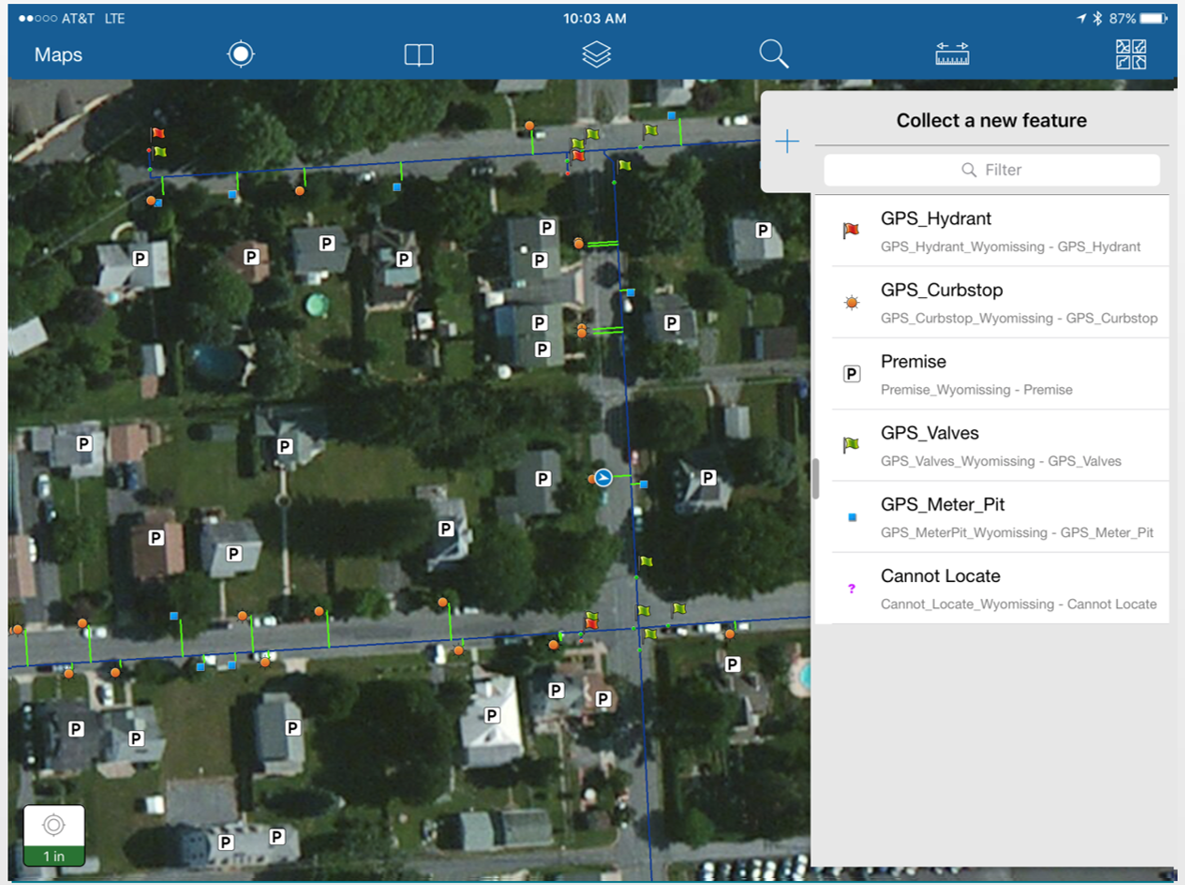
But it doesn’t stop there. Through GIS, we have also been able to streamline information collection. Throw away clipboards and paper forms. Instead, field team members simply need a mobile device. Customized data collection apps allow field teams to gather data and pictures with smart devices - and that information is directly populated into your GIS map. No filling out forms. No copying forms into spreadsheets, or rewriting information. One place to collect, one place to review.

#4 - It's meaningless if you can't access it.
The power of GIS lies in creating meaningful data that's there when you need it. Maintenance records, history, comments, and photos - wherever you are. Data is no good if you can't find what you need when you need it. How many projects were put on hold, or at least delayed, because someone, somewhere, had a paper that you couldn’t get to? How many emergencies were delayed because file hunting took longer than it should?
When your assets are in the cloud - when you utilize GIS for asset management - projects don’t stop. And emergencies? You’re ready for them too. GIS systems offer the convenience of accessing data from a desktop browser or mobile app. That means you access what you need whether you're in the office, in a meeting, or out in the field.
#5 - You can benefit from GIS, even if you you're not sure how.
Re-configuring your entire asset management system to GIS sounds intimidating. However, the benefit of GIS is its potential for growth. We’ve worked with municipalities that wanted to start small. All they wanted was pictures to be accessible in the field. So, instead of storing photos on hard drives- we connected them to a map. So when a crew arrives to repair an underground utility, they can quickly understand the configuration before they start digging. We’ve also worked with utility teams that went bigger- digitizing records for every single pipe, valve, and hydrant in their system. Everything they own including scans of hand-written plans accompanying their location.
GIS is here for what you need it for. For many, starting small and simple is a great first step. Consult with our GIS team to jumpstart your data collection and analysis.
Get your Assets in the Cloud: Utilizing GIS for Asset Management
The urgency of going remote quickly identified gaps in existing systems. Many have been forced to use tools that have always been at their disposal- but often overlooked. GIS has always been an advantageous opportunity for asset management. But, recent events have proven that getting assets into the cloud is absolutely critical, and should be a priority.

GPS Data Capture
So many people rushed out of their facility with urgency- with no idea what the restrictions would be on returning; or, no concept that they’d be gone for quite so long. For some, simple things as lunch boxes were accidentally left behind. For others, plans and documents that help things move forward- are still sitting exactly where they were left.
For years, organizations have identified ways to stop relying so heavily on paper. Overfull filing cabinets, messy desks, and printing costs are all contributors to this goal. But, being forced to work remotely has proven to be the catalyst that many need to, finally, stop relying on paper.
For asset management, in particular, having consistent and constant access to the most up-to-date information is crucial to maintaining operations effectively.
But the need to have asset information accessible is not new. For years, asset management has been a point of contention for many. What is the most efficient, the most effective, the most valuable… the best way to manage assets?
Cloud-based infrastructure through GIS has always been an advantageous opportunity for asset management. But, recent events have proven that getting assets into the cloud through GIS is absolutely critical, and should be a priority.
Here are 5 reasons that GIS is a game-changer for asset management.
1. Always at your fingertips
“Let me look through my files” is a thing of the past. What happens when you’re in an emergency? What happens when your paper files aren’t accessible? When it comes to asset management, the most important and crucial question is, “Can you find it when you need it?”
For many, going digital began long before this. You see- going digital, using the cloud, creating apps to collect data, none of this is unique to GIS. It’s the incorporation of geographic location and maps that changes the game.
You might already store digital photos of all of your assets. Or scan important updates that relate to construction or modifications to the systems you manage. But- what good are those folders and files- if you can’t find what you need when you need it?

GIS to Document Field Photos
Because in an emergency, you might not just need a picture of any water valve. You need a picture of the exact water valve that resides exactly where your crew is standing.
With GIS, the information you need is always there when you need it. The connection of asset information to location makes asset management easier, and more forward-thinking than ever before.
Here, there, anywhere, your information is accessible. Smart phones, computers, tablets, the digital list is endless. It’s where you need it, when you need it.
Most reports are showing that organizations across the globe have been moved to reconsider what work looks like. This includes remote work becoming a “new normal”. Being forward-thinking means being prepared for the future. Having your assets managed for the future, means having information at your fingertips- no matter where you are or when you need it.
2. Always up to date
One of the most valuable capabilities of GIS is its ability to be constantly updated. Paper plans are only good for the moment in which they are printed. Any changes force plans out of date, and in many cases, out of use.
Consider construction of a utility as a great example. An engineer designs a utility plan. The design plan (paper) gets passed on to construction. During construction, changes are, inevitably, made to the original design plan. These markups are often written on the design plan, forming the basis for the final record “as built” plan.
Sounds like a decent workflow, right? But, what if the design plan wasn’t on paper? What if it was accessed through a tablet? And, during construction, a tablet could be used to make markups. Our GIS team updates the map, and now the plans that you- or anyone- have in their hands at any time are always the right plans, always the most up to date plans, and always they plans they need.
3. Always moving
Let’s think back to the last example- the workflow of passing and updating and editing paper plans. How many projects were put on hold, or at least delayed, because someone, somewhere, had a paper that you couldn’t get to?
This point- GIS keeps things moving- is perhaps one of the key points that organizations learned over the past few months.
When your assets are in the cloud, when you utilize GIS for asset management- projects don’t stop. And emergencies? You’re ready for them too. You shouldn’t be spending time looking through your files, coordinating “get that paper to you” time, or even having to deal with the aftermath of an emergency that was poorly prepared for. Find it, use it, have it- all when you need it.
4. Always together
GIS for asset management also means that everything lives together in one spot. Project notes, locations, pictures, data, it is all embedded together, associated with the geographic point.
What this means is no longer trying to squeeze 3 sentences of notes into the small margin of a paper plan. What this means is no longer having post it notes and scrap paper circulating everywhere. What this means is everything stays together. Everything has a spot. Everything, is where it should be.
Even the simplest maps might have extensive comments that make the map meaningful. Instead of printing and writing- embed a note on a digital map. Now, it’s accessible for many and meaningful to all.
5. Always able to grow
Re-configuring your entire asset management system to GIS sounds intimidating. We get that. But what we love about GIS is its growth opportunity.
We’ve worked with municipalities that only wanted to start small. All they wanted was for field pictures to be accessible in the field. So, instead of taking millions of pictures and storing them in folders on their hard drive- they connected these to a GIS map. So when a field crew arrives to repair an underground utility, they can look at a photo of the installation and understand the configuration before digging it up.
Just pictures. Pictures attached to location create valuable information. Just pictures then expands to more- description of the project, notes about issues or concerns, maintenance records. It’s a simple start of implementation, with the power to grow into a hugely dynamic resource.
We’ve also worked with utility teams that go much bigger- digitizing records for every pipe, valve, and hydrant, everything they own including scans of hand-written plans.

GIS as a Record Management System
We’ve even done projects that extend further. One municipality is utilizing GIS as a records management system, not just assets. Original invoices, information on who installed pieces, everything they could ever need to know- digital, at their fingertips, up to date, all in one place.
The point is, that GIS is here for what you need it for. For many, starting small and simple is a great first step. Then, add something else. Then, add some more. The more you use it, the more excited you’ll be for all of the ways it can grow.
The urgency of going remote quickly identified gaps in existing systems. Many have been forced to use tools that have always been at their disposal- but often overlooked. Across the board, lessons have been learned about how organizations have functioned in the past, and should look to function in the future. GIS for asset management? That’s forward thinking.
#ProblemSolved: Our GIS Team is here to help. If you have questions, send an email to Al Guiseppe, PG at al.guiseppe@ssmgroup.com or give a call to 610-898-3049
SSM is assisting The Walnutport Authority with modernizing their operational support model by moving from paper sources to Geographic Information Systems (GIS).
SSM has developed a versatile tool and process for gathering data, and tracking and presenting progress on compliance with the City of Philadelphia’s Building Energy Performance Program (BEPP).