

Boiler Replacement Design
SSM prepared construction documents for the installation of a dual fuel 1,200 HP boiler to replace a 67 year old water tube boiler.

Confidential Client - Data Center
New York
SSM prepared construction documents for the installation of a dual fuel 1,200 HP boiler to replace a 67 year old water tube boiler. The new boiler will provide a better energy efficiency and turndown ratio for off-peak conditions. The project included replacement of two 75,000 lb/hr deaerators with custom deaerators that could be modified to fit the available space.
SSM utilized high definition laser scanning to document existing conditions in the 3 level boiler building. SSM mechanical engineers prepared a detailed flow diagram of existing piping and instrumentation.
The structural scope included design of a boiler access platform, roof modifications for the new stack, and structural support of the economizer located on the third floor. The existing steel was detailed using 3D laser scanning and field measurements to identify scope of removal and replacement of deaerators located on the third floor.
The electrical design included power, instrumentation, and controls. SSM electrical engineers provided a short circuit analysis and breaker coordination study for replacement power systems. The instrumentation and controls was designed to integrate with owners legacy building management system while maintaining owners preferred boiler combustion controls, boiler water level controller, valves, and sensors.
Existing Structure and Landscape Conditions
SSM utilized high definition laser scanning equipment and software to quickly and accurately capture the existing structure and landscape conditions.
ATKIN-OLSHEN and CVM
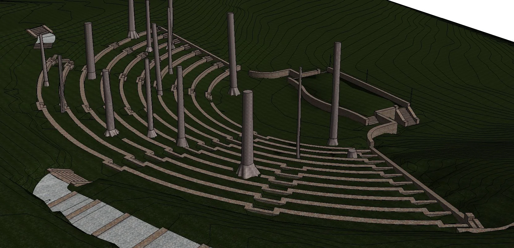
Swarthmore College Scott Amphitheatre
Scans: 8Scan Time: 1 day

Working for Project Architect Atkin-Olshen, and CVM, the structural engineers responsible for designing a proposed removable canopy and supporting structures for the existing 50-year-old open-air Amphitheatre, SSM utilized high definition laser scanning equipment and software to quickly and accurately capture the existing structure and landscape conditions. These services were employed to enable the project team to design the renovations in a 3‑D environment. The Revit model and accompanying point cloud allows the team and owner to design and then view the effects their design will have on the multi-terraced levels, stone retaining walls and mature trees. In addition, SSM utilized an existing topographical survey plan that was imported into Revit and used as supplemental background information.
SSM delivered the following:
An accurate 3D model of the Ampitheatre developed in Revit. The point cloud data was included in the Revit drawing.
Leica Tru-View of each scanner position. Leica Tru-View is a free web-based tool allowing the user to view the point cloud and field photography together, to easily and quickly “re-visit” the scanned areas of the building. Tasks such as panning, zooming, acquiring measurements and mark-up tools are all functions of the Leica Tru-View Software.

High Definition Scanning and AutoCAD Modeling
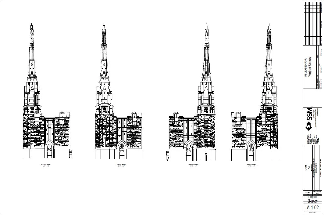
SSM utilized high definition laser scanning equipment and software to quickly and accurately capture the existing facade conditions of the church’s 150-foot bell tower.

BRYN MAWR PRESBYTERIAN CHURCH | EXTERIOR SCAN
CVM Engineers
Bryn Mawr, Pennsylvania
SSM utilized high definition laser scanning equipment and software to quickly and accurately capture the existing facade conditions of the church’s 150-foot bell tower. These services were employed to enable the project team to understand the design the displacements of the masonry elements in a 3‑D environment to ascertain structural conditions. The AutoCad elevations and sections and accompanying point cloud allows the team and owner to design and then view the existing conditions and effects of any proposed repairs.
SSM delivered the following:
Elevation of each side of the tower portion of the church delivered as a 2D Autocad drawing. The portion of the tower, from the parapet base to the top of highest point was highly detailed to show cast stone ornamentation and the location of each of the stones in the aforementioned portion and include general geometry for the balance of the tower (to ground level). SSM documented planar distortion to indicate how far the top portion of the tower as well as the parapet walls may be leaning.
Leica Tru-View of each scanner position. Leica Tru-View is a free web-based tool allowing the user to view the point cloud and field photography together, to easily and quickly “re-visit” the scanned areas of the building. Tasks such as panning, zooming, acquiring measurements and mark-up tools are all functions of the Leica Tru-View Software.
HIGHLIGHT: The 11 scans were performed in 1 day.
