

City of Philadelphia Building Energy Performance
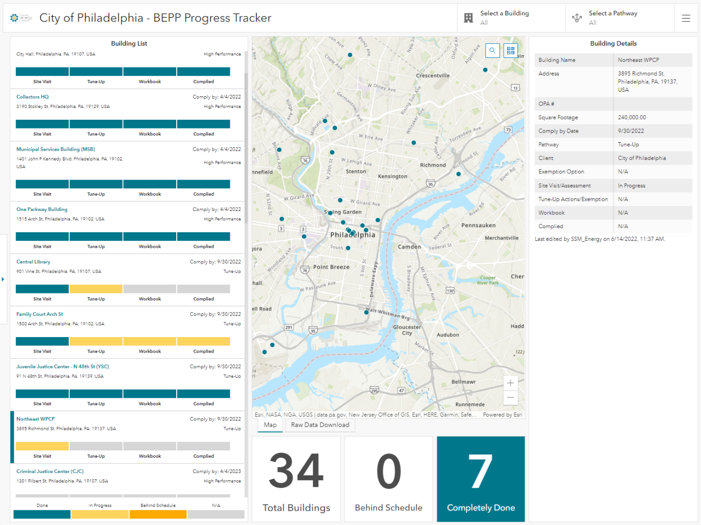
SSM has developed a versatile tool and process for gathering data, and tracking and presenting progress on compliance with the City of Philadelphia’s Building Energy Performance Program (BEPP).
Building Energy Performance Program Data Collection and Tracking GIS Dashboard | Energy & GIS Services
SSM has developed a versatile tool and process for gathering data, and tracking and presenting progress on compliance with the City of Philadelphia’s Building Energy Performance Program (BEPP).
All non-residential buildings over 50,000 SF are required to review energy systems and controls periodically to bring them up to a good state of performance – this amounts to a vast and increasing quantity of data.
Developed in ArcGIS Online for desktop or mobile access, the BEPP Workflow gives SSM the capability to standardize and streamline the building tune-up and exemption processes for our clients, as well as provides the City of Philadelphia capability to monitor and share the progress of tune-ups of their own buildings through an ArcGIS Online Dashboard. We can continually optimize the Workflow and Dashboard to the City’s needs, client requests, and BEPP updates.
SSM is committed to helping property owners to save energy, reduce emissions, and improve tenant comfort. Once a BEPP project is underway, this app tracks due date, progress, compliance pathway, and other information. Our GIS platform also collects the data entered on iPads during our field visits, which then populates the required BEPP Excel workbook. This streamlines the entire process, reducing the cost of each tune-up to the client.

Walnutport Authority
SSM is assisting The Walnutport Authority with modernizing their operational support model by moving from paper sources to Geographic Information Systems (GIS).
SSM has developed a versatile tool and process for gathering data, and tracking and presenting progress on compliance with the City of Philadelphia’s Building Energy Performance Program (BEPP).
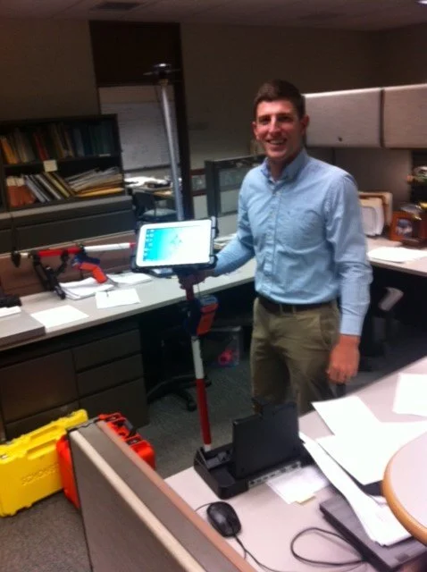
SSM is assisting the Walnutport Authority in modernizing their operational support model by moving from paper sources to Geographic Information Systems (GIS). SSM is completing this project in 3 parts: Data collection using an Arrow GPS unit, converting the data into GIS layers, and making the information available online to the operational crews via ArcGIS Online.
The collection portion of the project is anticipated to be finished by the end of November 2022. The GIS component will be done by early December, with online development and training to take place shortly thereafter.
Pennsylvania American Water Company
SSM provided GPS data collection services for every asset owned by PAWC in 6 of their Southeast systems and 11 of the Northeast systems.

GPS Data Collection
Completion of a $706,000 contract for GPS Field Data Capture. SSM provided GPS data collection services for every asset owned by PAWC in 6 of their Southeast systems and 11 of the Northeast systems.
Data was collected using survey grade GPS equipment that is capable of sub- centimeter accuracy as well as the recording of vital attribute data. After the assets (i.e. hydrant, valve, curb stop, manhole, cleanout etc.) were captured in the field, they were then integrated into the existing GIS data, providing PAWC with the most spatially accurate data available. In total the field crew was responsible for capturing over 200,000 assets on both water and wastewater lines over roughly 125 square miles in 5 counties.
The benefits of knowing exactly where all water and wastewater assets are located are numerous as well as cost effective to a utility provider. The amount of money and time saved searching and in most cases digging for buried and missing utilities will be drastically reduced at the conclusion of a GPS data collection project. The updated spatially accurate GIS data will provide the operations staff with an invaluable tool in the field to locate and manage their vast assets.
Project Statistics:
PAWC Yardley System; 28,576 points captured
PAWC Norristown System; 70,238 points captured
PAWC Royersford System; 37,354 points captured
PAWC Coatesville System (Water and Wastewater); 7,336 points captured
PAWC Bangor/Nazareth System; 28,000 points captured
PAWC Lehman Pike (Water and Wastewater); 16,543 points captured
In total the field crew was responsible for capturing over 208,000 assets on both water and wastewater lines; over roughly 125 square miles in 5 counties. The average collection rate per person per day was 332 points.

South Heidelberg Township
SSM has worked with South Heidelberg Township on the development and deployment of field inspection applications using mobile Geographic Information Systems (GIS) technology. This technology will modernize the Township’s operations and maintenance as well as contribute to a more efficient workflow


Field Inspection Applications Using Mobile GIS Technology
SSM is working with South Heidelberg Township on the development and deployment of field inspection applications using mobile Geographic Information Systems (GIS) technology. This technology will modernize the Township’s operations and maintenance as well as contribute to a more efficient workflow. SSM is providing multiple inspection applications, all of which include training to Township staff on how to use the GIS applications.
Stormwater Facilities Inspection Applications
Populated the existing GIS database with current information, such as outfall descriptions and existing land use within outfall drainage areas.
Deployed mobile GIS-base d field inspection applications for the routine inspection of stormwater outfalls within the Township. Data collected using the outfall inspection applications will be used to generate PaDEP MS4 Outfall Field Screening Report.
Development and deployment of field inspection applications to gather information and assess the condition of stormwater infrastructure assets throughout the Township.
Transportation Inspection Applications
Development and deployment of mobile GIS-based field inspection applications for the routine inspection of street signs and road conditions within the Township.
Sanitary Sewer Manhole Inspection Application
Development and deployment of GIS-based field inspection application for the routine inspection of sanitary sewer manholes within the Authority’s system.

Norristown Municipal Waste Authority
SSM has provided continuous assistance to the NMWA for over 15 years for compliance with a PA Department of Environmental Protection Consent Order and Agreement to eliminate combined sewer overflows (CSOs) and excessive Inflow/Infiltration from the sewage collection system.
SSM has provided continuous assistance to the NMWA for over 15 years for compliance with a PA Department of Environmental Protection Consent Order and Agreement to eliminate combined sewer overflows (CSOs) and excessive Inflow/Infiltration from the sewage collection system. Approximately 10,000 customers are served by the NMWA WWTP. SSM has performed extensive Inflow/Infiltration (I/I) investigations and program management, including manhole inspections, building and outside property inspections, and some smoke and dye testing of roof leaders, foundation drains and parking lot storm drains. SSM prepared and calibrated the hydraulic model of the Norristown Municipal Waste Authority’s 60-mile sanitary sewer collection system.
Sewer System Hydraulic Modeling and I/I Remediation
Phase 1 utilized GIS capabilities to create a working database.
Utilized PCSWMM to create a calibrated hydraulic model.
Phase 2 utilized database and model to determine future flow impacts and provide rehabilitation recommendations to reduce infiltration and inflow.
Develop and implement I/I remediation projects based on closed circuit television inspections and field inspections. Manage all construction projects related to I/I remediation.
Collection system modeling to develop a relationship between rainfall patterns and inflow patterns at the WWTP.
Performed computer modeling simulations of the NMWA sanitary sewer system in order to predict how proposed changes to the sewer system and corresponding CSO-003 would affect the system’s hydraulic conditions during a heavy storm event, as well as estimate the storage capabilities in the system.
GIS Mapping for Sanitary Sewer Rehabilitation and Investigation
SSM provided extensive GIS Mapping of the NMWA’s sanitary sewer collection system to include 60 miles of sanitary sewer. The GIS database was used to prepare and calibrate a hydraulic model of the sewer system and to provide maps for use in Inflow/Infiltration (I/I) investigations and program management, including flow metering locations (pre- and post-rehabilitation), manhole inspections, building and outside property inspections, some smoke and dye testing of roof leaders, foundation drains and parking lot storm drains. GIS Database management was utilized in order to map the results of televising investigations and flow metering, as well as to provide recommendations for non-invasive inflow reduction methods for property owners. SSM provided guidance to NMWA staff for collecting data from property surveys which was then incorporated into the GIS database. This mapping was later incorporated into the NMWA’s Combined Sewer Overflow - Long Term Control Plan for submission to the PA DEP, including the Nine Minimum Controls update for CSO 003.