

From the Farm to the Table: A Little Taste of SSM
Experts in the food industry should focus on just that- food. That’s why farmers, processors, distributors, and even restauranteurs all turn to SSM.
It takes a lot to bring a product to market. Experts in the food industry should focus on just that- food. Because after all, addressing needs such as: regulatory compliance, increased capacity, routine maintenance, and facility expansion shouldn’t take away from doing what they know best. That’s why farmers, processors, distributors, and even restauranteurs all turn to SSM. We help secure prime locations, plan more efficient warehouses and distribution centers, conduct feasibility studies, upgrade utilities and building systems, improve traffic flow, and expand operations. By taking the lead on the engineering side, we enable the food industry to focus more on their core business.
Poultry Farming
Structural Design Services | The design of a 275,000 gallon rectangular equalization tank included identifying IBC loading criteria, and calculations for design of CIP concrete walls and base slab.
New Public Water Supply | This water supply development project entailed conducting fracture trace analysis, locating potential well sites, overseeing test well drilling, designing well construction specifications, performing aquifer testing programs, analyzing pump test data, and preparing permit application materials for state and federal regulatory review.
Food Processing
Confectionary Manufacturer | Prepared annual stormwater NPDES site inspection reports.
Meat Processor | Performed various services including health and safety training and environmental audit of plant operations with regard to air, wastewater, hazardous substance, storage tank, and residual and hazardous waste regulations.
Brewing Facility | Performed an asbestos reinspection and mold investigation for potential purchase of an existing brewing facility
Bakery | Survey and civil engineering services for the design of a new 140-space trailer storage parking lot including bedrock depth investigation, stormwater management design, and electrical lighting design.
Warehousing and Distribution
Distribution Center | Provided comprehensive structural, mechanical, and electrical services to convert an abandoned 125,000 SF processing facility into a food products distribution center. SSM utilized high-definition scanning data to create a complete point cloud database in preparation for the retrofit and reuse.
Supermarket | Performed site design engineering services for the expansion to an existing Store. This design-build project included a site survey, creating an existing conditions base plan, developing construction drawings, which included site grading and stormwater management, utility relocation, and erosion and sediment control.
Gathering Places
Restaurant | Provided design of the mechanical, electrical, and plumbing systems for the conversion of a former furniture store into the 7,000 square foot restaurant and bar.
University Kitchen | Designed the mechanical, electrical, plumbing, and fire protection systems for student housing that included the conversion of existing housing units into a new kitchen facility and a serving and dining pavilion.

Celebrating Surveyors and Agriculture
Every year in March we take a week to celebrate the surveying profession. We celebrate the way our surveyors see the world differently.
March 23, 2021: National Ag Day
This month we joined The Agriculture Council of America (ACA) in celebrating National Ag Day. From understanding how food and products are made to valuing its role in the economy- we celebrate agriculture.
Over the past 20 years, SSM has provided more than 400 Agricultural Land Preservation Easement Surveys. Our team has surveyed and helped to preserve over 30,000 acres of Berks County Farmland.
An agricultural conservation easement is a permanent legal restriction on land development that limits future uses of land to agricultural purposes.
Our survey team provides services that combine land record research and a physical property survey and inspection. They identify existing easements associated with the land and any structures on the property that are present as a result of easements (utility pipelines, roadways, transmission wires and access points on the land). Our team utilizes conventional survey methods, GPS systems along with drone flight data to complete the surveys. Easement Survey plans and legal descriptions are drafted and become part of the final recorded documents for the project.
March 21-27, 2021: National Surveyors Week
Every year in March we take a week to celebrate the surveying profession. We celebrate the way our surveyors see the world differently: through the vision of making the world a better place, through the lens of technology, and through the eyes of precision and data. Surveyors see the world- from construction sites, to farm preservation, to insides of factories, and even to aerial site evaluations.
We celebrate our surveyors because of the accuracy, the expertise, and the care that they contribute to every project, to every challenge, and to every solution.
Since 1932, SSM has prided itself on being at the forefront of surveying expertise. Over those nearly 90 years, we have consistently refined our practices, while maintaining our values. Because when it comes to your projects- quality and precision are what you deserve.
We like to say that good surveyors take measurements and collect data. But great surveyors- our surveyors- take accurate measurements, gather precise data, and provide the care and attention that not any project needs, but your project needs. Because your projects shouldn’t just get done, they should get done correctly.
What we do best, is what you don’t. Expertise means having the skills, having the knowledge, and having the experience. Expertise is nearly 90 years of refining practices, nearly 90 years of pioneering technology, and nearly 90 years of mastering skills and solving problems. We pride ourselves on being the experts- so you don’t have to be.
Our survey team is here to help.
Boundary and Retracement Surveys
ALTA/ACSM Title Surveys
Drone Applications
Landfill Surveying
GPS and VRS Surveying
Aerial Mapping Control
Geodetic Control
Municipal Control for GIS Applications
High-Definition Laser Scanning
Building and Construction Stakeout
Topographic Surveys
Agricultural Conservation Easement Surveys
As-Build Site and Utility Surveys
Subdivision and Land Development Surveys
Bathymetric Surveys
Meet the Surveyors: Check out our interviews with 3 of SSM’s survey team members.

Sam Zook, PLS
Sam is the Director of Surveying and Data Capture. Read his interview here!

Tom Rowe, PLS
Tom is a Chief Surveyor. Read his interview here!

Zane Britton
Zane is a Survey Crew Chief. Read his interview here!

Surveyor Highlight: Zane Britton
The 4th week of March is Surveyors Week, which is a week to celebrate the impressive things Surveyors do for the world and celebrate their impacts. What do you love about surveying?
An Interview with Zane Britton.
Zane is a Survey Crew Chief at SSM.

What do you love about surveying? Why do you do what you do?
The things I love about surveying are the daily challenges we face. Every job has different challenges that keep us sharp in problem solving and critical thinking. I also enjoy that we are outside daily. (I love it more when it’s warm out!)
What is something about surveying that makes you excited to talk about? Let your nerd flag fly!
What gets me excited about surveying is the variety of work that we do. From flying drones, to high-definition scanning, construction stakeout and boundary surveys. I actually get to see knowledge that I learned in school get put to use.
Do you have a favorite project or experience?
My favorite project so far is a Senior Living Center in King of Prussia. We were there for months on end and able to see it go from being just dirt in the ground to now an 11-story building.
What’s your favorite type of project?
I’d say my favorite type of work is going to the farms for boundary surveys. Nothing is more pleasing than finding a 100 year-old marble monument or stone in the middle of woods where you never think you’d find it.
What do you wish people knew about surveying?
The one and only think I wish people knew was that we aren’t standing on the side of the road taking pictures. We’re actually measuring precise angles and distances.
Why surveying at SSM?
I’d say working at SSM is better than anywhere else because of the camaraderie it brings. I don’t feel like just another number, it feels more like a family. We work 40 hours a week together and we all still hang out outside of work. That just shows the type of relationship we have.

What does Zane outside of work do for fun?
Outside of work I enjoy doing home projects on the house I bought. I’m learning other skills that I will have for the rest of my life. I also enjoy hanging out with friends and doing things that get me out of the house.
#ProblemSolved: Our Survey and Data Capture Team is here to help.

Surveyor Highlight: Tom Rowe, PLS
The 4th week of March is Surveyors Week, which is a week to celebrate the impressive things Surveyors do for the world and celebrate their impacts. What do you love about surveying?
An Interview with Tom Rowe, PLS
Tom is a Chief Surveyor at SSM.
TOM ROWe is a chief surveyor in ssm’s survey and data capture department. this year he’ll be celebrating his 36th year with ssm. tom is a jim thorpe native, a penn state lover, and a pappy to 4 beautiful little boys.
What do you love about surveying?
The thing I love most about surveying is the mix of the various aspects of our work. From research, to planning, to field work, and ultimately to drafting up the results.
What’s the thing about surveying that makes you excited to talk about? Let your nerd flag fly!
One thing about property surveys is sometimes you need to become a little like Sherlock Holmes. You’re like a detective trying to utilize the clues given in order to come to the correct solution.
How would you describe what it is that you do to an elementary-aged child?
Once I was asked to give an overview and demonstration of surveying to a pack of cub scouts working towards a specific merit badge. I described my job by saying the measure things for a living. I also showed them a picture of Mount Rushmore and asked them who they see. After they responded “presidents” I unfolded the picture a little more and said, “but to me, they are 3 surveyors and another guy".” I did this to demonstrate that surveying is an ancient and honorable profession.
Do you have a favorite project, experience, or type of work?
I definitely love the property survey work. I have been on so many surveys for these oh so many years so it’s difficult to pick a few favorites. I still get a kick out of doing some background work, research and calculations, then going to the field and walking right up to the missing property corner I was hunting for!
What do you wish people knew about surveying?
I wish some people would be aware that sometimes surveys may not come out in their favor. On numerous occasions I have informed clients that I might not give them the answer they want to hear.
What are some other meaningful things we should know about your time surveying with SSM?
My wife and I have been married for nearly 34 years, and we met at Northampton County Courthouse. She was working in the Assessor’s Office and I came in to research a property we were going to survey… and she waited on me! So yes, my SSM career started before my marriage! My 2 daughters were born thereafter. Ashley and Shannon have given us 4 grandsons at this point. Funny how generations work: I come from all boys, had all girls, and now have only grandsons!
What makes you unique- what are the little known facts you use in icebreakers?
My little known fact is I have NEVER had a cup of coffee in my life! Another interesting fact is that a surveyor from my hometown lived just a few doors down the street and was pretty much responsible for my apprenticeship in surveying.
What does at-home Tom like to do in his free time?
Away from SSM, my biggest hobby is I love to sing. I was involved with a group known as The New Approach for nearly 18 years. Each summer we would perform 3 shows with all of the proceeds going to help fight cancer. This group was together for a total of 47 years, raising around 1 million dollars through that span! The group eventually disbanded. But, my wife got me a karaoke machine for Father’s Day recently, so we crank it up from time to time.
#ProblemSolved: Our Survey and Data Capture Team is here to help.


Surveyor Highlight: Sam Zook, PLS
The 4th week of March is Surveyors Week, which is a week to celebrate the impressive things Surveyors do for the world and celebrate their impacts. So tell us- what do you love about surveying?
An Interview with Sam Zook, PLS

Sam Zook is the Director of Surveying and Data Capture at SSM. This year, he’ll be celebrating his 9th year of service with SSM. Sam is an achiever, a learner, and a relator. He’s also a dad of boys who loves fresh water fishing and trips to hardware stores.
Sam Zook is the Director of Surveying and Data Capture at SSM.
The 4th week of March is Surveyors Week, which is a week to celebrate the impressive things Surveyors do for the world and celebrate their impacts. So tell us- what do you love about surveying?
I love the research precision of survey.
You have kids- how do they describe what you do?
My son once did a homework assignment where he wrote: My dad is a surveyor. He measures land and makes plans for buildings.
Do you have a favorite project or experience with surveying?
My favorite type of projects that we work one are the Farm Surveys that we do for Berks County. But as far as a sense of accomplishment, we worked with Doylestown Hospital on an expansion and that one was a favorite project to complete.

There are a lot of different types of surveys. Which one is your favorite?
Boundary surveys are my favorite type of survey. They are like a research project, and scavenger hunt. It’s challenging and exciting like putting together a puzzle.
What makes being a surveyor at SSM great?
The effort that SSM puts in to keep us on the cutting edge of practices and technology as well as the overall company culture all make SSM a great place to be a surveyor.
What makes outside-of-work Sam happy?
Outside of SSM I enjoy doing anything outside. But, I especially enjoy landscaping and working in the yard.

#ProblemSolved: Our Survey and Data Capture Team is here to help. Send an email to Sam Zook, PLS at sam.zook@ssmgroup.com.

Surveying in the Fall
Fall is a great time for surveying. The weather is more temperate than Summer or Winter, and it is not quite as wet as Springtime. But there’s one other key to the season that makes Fall a great time for surveying: falling leaves.
For many, the Fall season brings great joy. The crunch of leaves, the extra breeze, and yes, the smell of pumpkin flavoring and warm apple cider.
For surveyors, whose days are spent almost fully outdoors, the start to Fall is a welcome change in climate. Most of our surveying team considers Fall the best time to survey. The weather is more temperate than Summer or Winter, and it is not quite as wet as Springtime. But there’s one other key to the season that makes surveying in the Fall better, stronger, and more efficient: falling leaves.
As the leaves fall off the trees, you should make a point to get your data collected! Performing surveying and data collection at this time of the year is actually less difficult. Because measured spaces need to be visible, as leaves fall- more data is able to be captured in a simpler, and often faster, fashion. Aerial imagery from a vertical position becomes clearer. And the same can be said for horizontal measurements. Without large shrubs and leaves on the trees, our surveyors are able to survey faster and more accurately. This is especially true in wooded areas because more measurements can be taken from less setups. That means more data, less time.
A common term for this idea is leaf-off imagery. This is as opposed to leaf-on imagery. As expected, leaf-on refers to foliage on trees or thriving shrubs. Leaf-off means no foliage or a decreased amount of shrubs.
Leaf-off imagery is particularly essential when mapping with contours and ground elevations form aerial imagery. When capturing leaf-on imagery, large portions of an area cannot be mapped accurately due to tree coverage. On the other hand, with leaf-off imagery, the photogrammetry processing is able to determine elevations more accurately through the gaps in tree branches that are not visible when the leaves are on.
As we embrace the season, we also embrace the opportunities that Autumn presents for serving our clients in an even better, an even more efficient, and an even more precise manner.
#ProblemSolved: Our Surveying Team is here to help. Send an email to Sam Zook, PLS at sam.zook@ssmgroup.com or give a call to 484-388-5989

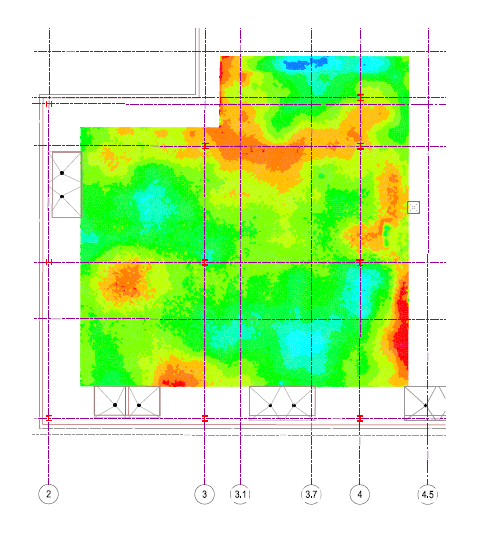
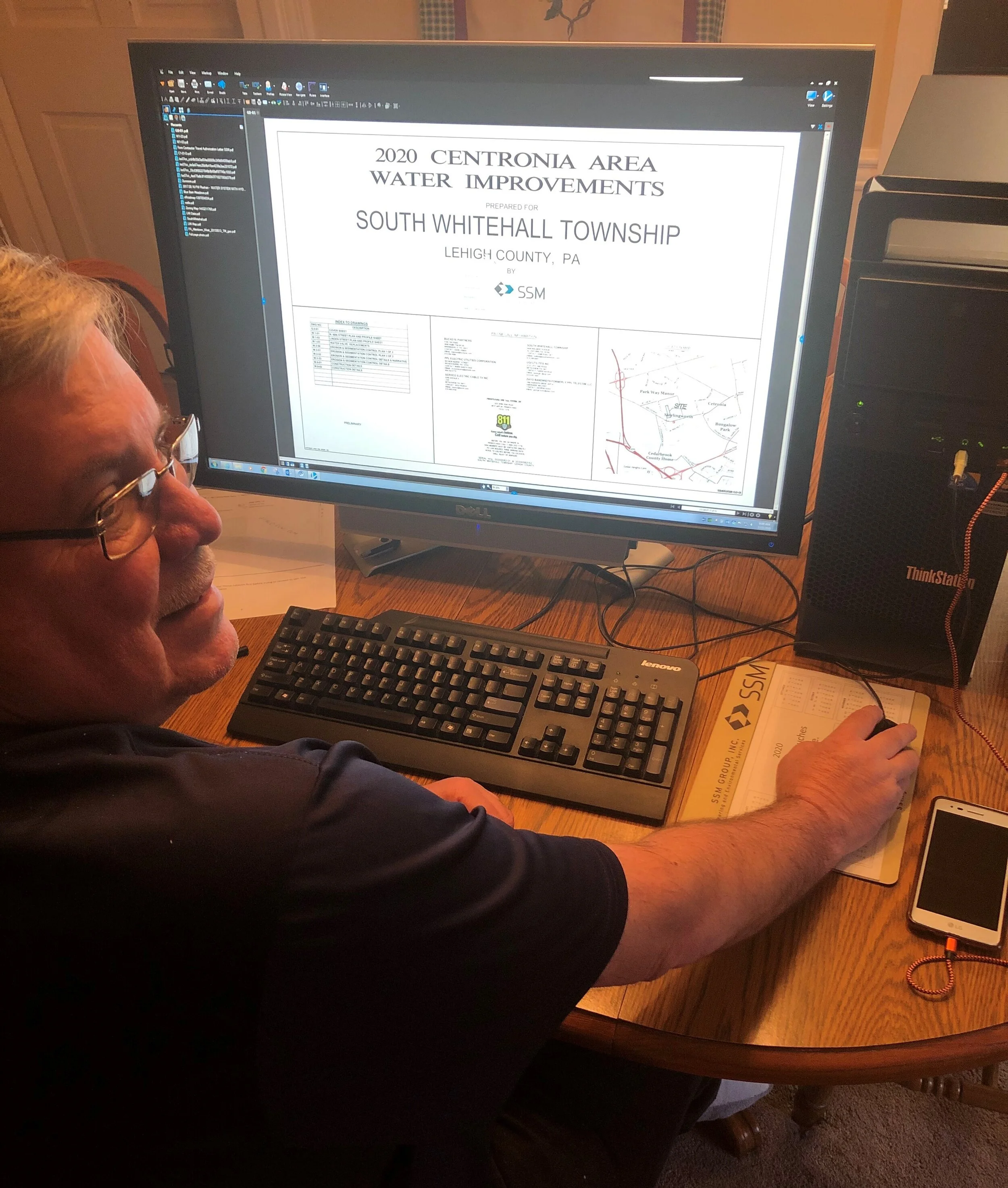
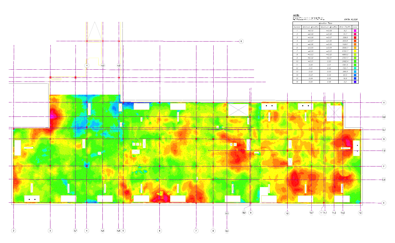
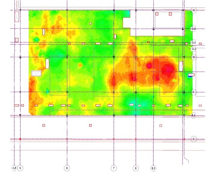
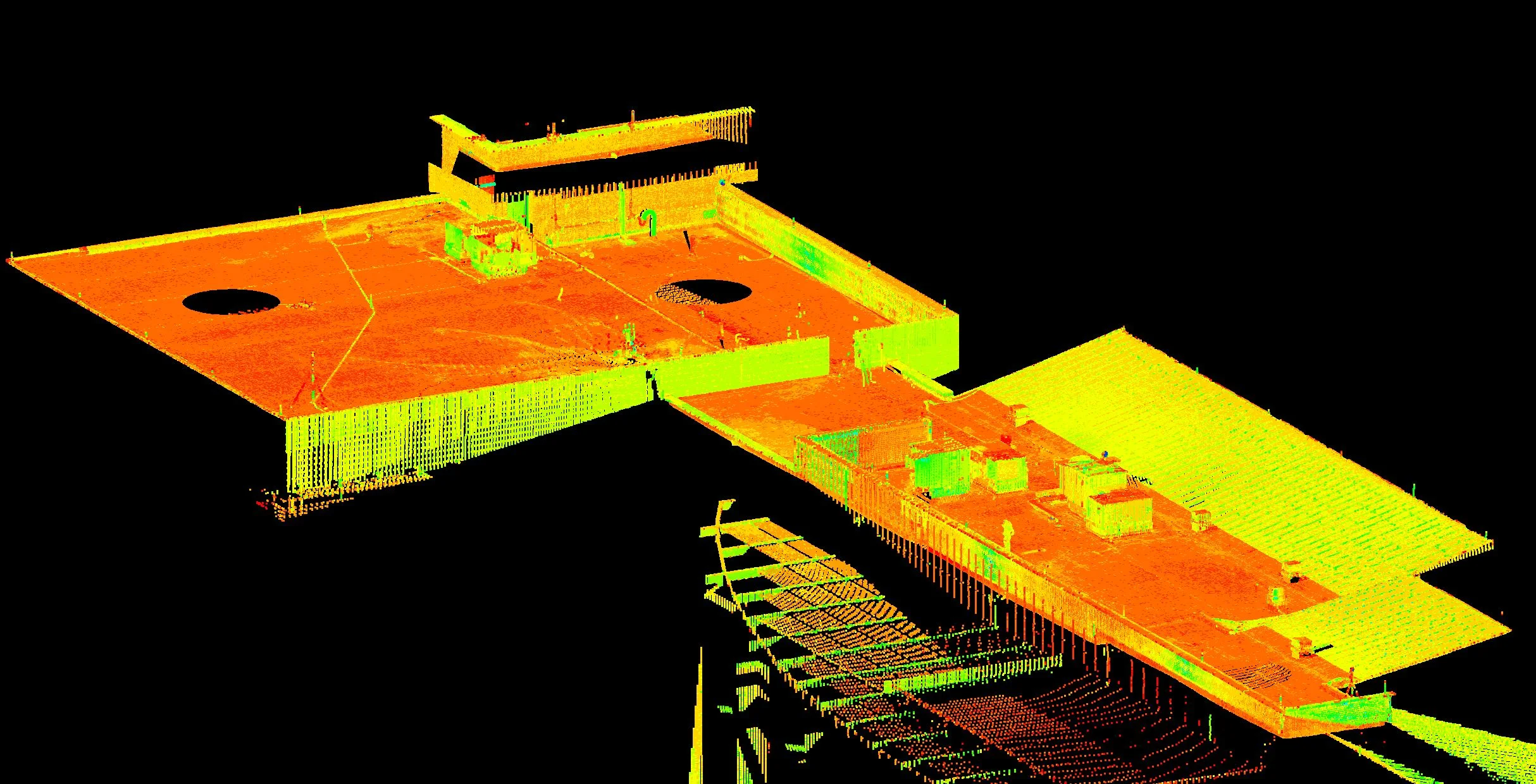
High-Definition Laser Scanning to Measure Floor Flatness
High definition laser scanning offers the best precision, efficiency, and accuracy to the process of measuring floor flatness. With speed unlike manual measurement, and collection of millions of points, digital scans identify and distinguish exactly where floors stand- competitively outshining historical practices.
Getting to the Bottom of It

Construction supervisors, contractors, architects, building developers, facility managers, inspectors, engineers, and other key stakeholders in facility and building construction all know well the critical concern that is floor flatness. Exact flatness in concrete floors is critical to efficient facility functioning, maximum floor tolerance, maintaining operations, and successful architectural design.
Down to minute measurements, 1/16th of an inch, floors that are not exceptionally flat cause major disruptions to existing facilities, or halt construction of new ones.
For industrial facilities- machinery, forklifts, handling equipment, and vertical storage all require precise concrete floor flatness. Lack thereof can increase chance of injury, loss of product, and damage to large equipment. Although rarely noticeable to an untrained eye, the impacts of a floor that is not flat are impossible to ignore.
For architects as well, modern designs require a similar preciseness. For example, glass walls and other popular design elements are all at the mercy of the flatness of the floor they will be placed on.
Rehabilitating and revitalizing existing structures also have a need for measuring floor flatness. Of primary concern among these are the settling of concrete over time. To successfully redevelop an existing facility, identifying the floor’s flatness is critical to successful tolerance and utility.
It is clear that measuring the precise flatness of a floor is of utmost priority to building development teams. But the priority is not new. Experienced teams are well-versed in the role and impact this priority has on timeline and long-term successfulness of building projects.
Although a historical concern, innovative teams are frequently searching for a better way. These teams are privy to the role that precision, efficiency, and accuracy all play in bringing construction projects to fruition. Because just measuring the floor’s flatness isn’t enough. The measurements should be precise. They should be done efficiently. And, the results should be accurate.
High definition laser scanning offers the best precision, efficiency, and accuracy to the process of measuring floor flatness. With speed unlike manual measurement, and collection of millions of points, digital scans identify and distinguish exactly where floors stand- competitively outshining historical practices.
Cutting-Edge Practices and Technology
Throughout the years, measuring to calculate F numbers (flatness) has taken a variety of methods. It wasn’t too long ago that technicians would lay a 10-foot straightedge on finished floor, identifying gaps and using these to calculate flatness. More recently, crews are deployed to walk slabs of concrete, take a variety of measurements, and generate a resulting calculation.
Both of these avenues leave great room for human error. In some instances, the straightedge method even presents discrepancies from technician to technician. In a similar regard, both of these tactics offer extensive manual labor, inhibiting work timelines.
In construction, time and value are often seen as contradicting. Developers are frequently forced to accept that accurate, precise results go hand in hand with extended timelines. In considering the value of precise floor measurements, it would be assumed that the process must be long to be accurate. But with 3D scanning, neither time nor accuracy must be sacrificed.
Laser scanning for floor flatness dramatically improves the three core areas of concern: precision, efficiency, and accuracy.
Here’s how it works:
Our survey and data collection technicians deploy cutting-edge scanners to the construction site. In just a few minutes, the floor space is scanned, collecting over thousands of single points that together form a digital rendition of the space at precise measurements.
This is repeated a number of times, each time utilizing the same control or benchmark within the space. Multiple scans of the same space is a practice that increases accuracy. Utilizing the benchmark ensures precision among each scan. The scans are transferred to digital format, creating a 3D point cloud- all of the multiple scans, millions of individual points, layered on top of one another, and anchored by the control.
Digital scans of a space offer elevation information- identifying clearly the floor’s flatness. But scanning technology also offers the capability to calculate F numbers just as manual labor aims to do. Therefore, the technology reaches the desired conclusion in a better way, a faster way, and a more effective way.
Precision. Efficiency. Accuracy.

By collecting millions of points in minimal periods of time, laser scanning outshines manual labor and calculations. Technological advances decrease the opportunity for human error, and decrease the amount of time it takes to collect more information. And, this technology means not only more data, but more capabilities with that data.
21st century facilities shouldn’t be built with last century tactics.
We know that investing in cutting-edge technology and implementing cutting-edge practices changes the game for our clients. The outcome is evident- high definition laser scanning is the best way to measure floor flatness with precision, efficiency, and accuracy.
Looking to talk more about using scanning to measure floor flatness? Our Survey team would be happy to help. Send us an email at information@ssmgroup.com
#ProblemSolved: Read more about Survey and Data Capture.


Matt Smith Receives Certification as Drone Pilot
Matt Smith, Survey Crew Chief has received his certification as a FAA Certified Remote Pilot.

MATT SMITH | Survey Crew Chief
Matt Smith, Survey Crew Chief has received his certification as a FAA Certified Remote Pilot. Smith is one of three certified pilots at SSM. He is a graduate of Pennsylvania College of Technology, Associate of Applied Science and Forest Technology, with over 15 years of surveying and data capture.
On June 21st, 2016 the FAA finalized a new regulatory framework for small, unmanned aerial systems. Titled Part 107, these new regulations created a new drone certification process that covers the majority of low-risk, commercial UAS flight operations for all commercially operated drones. Commercial refers to any kind of flight operation that can be tied to economic benefit. These new regulations were implemented on August 29, 2016.

Drones are a powerful solution for monitoring construction, documenting infrastructure on expansive sites, and capturing hard-to-reach details.
Small Imperfections Matter
From high-speed racetracks to concrete floors measuring and modeling large surfaces can highlight small imperfections.
For complex surfaces or large areas of surfaces that require high levels of flatness or levelness, using a high definition laser scanner offers millions of coordinate data points for verification or detection of anomalies that cannot otherwise easily or quickly be acquired. From offices to high density storage facilities, synthetic surface playing fields, to high-speed race tracks, the ability to rapidly and accurately measure and model large surfaces can highlight the small imperfections that can make a big difference.

In West Whiteland Township, post-construction high definition surveying was utilized over 12,000 square feet of concrete floor to identify irregularities in placement that prohibited the installation of finishes, equipment and furnishings. Contour plans with color banding and spot elevations to demonstrate where problem areas were located, with 1/8-inch accuracy aided the client and contractors to swiftly repair and to rule out structural deficiencies. A similar analysis was performed for the roof to identify slope and stormwater drain placement.
FOR MORE INFORMATION: Patrick McCoy, PE, LEED AP, CSDP